- European Travel Weather ›
- Greece ›
- Crete
Crete, Greece Weather and Climate
Crete historic tamperature and precipitation maps for vacation planning.
Crete is a large island full of interesting sites, including the Palace of Knossos, the Lasithi Plateau, and the Sumeria Gorge.
The historic climate data in the charts below comes from Heraklion or Iraklion, the capital of the island of Crete and one of the largest cities in Greece. The ruins of Knossos are nearby; you can walk to them from the city. The Venetian fortress called Rocca al Mare, built in the 14th century, guards the harbor.
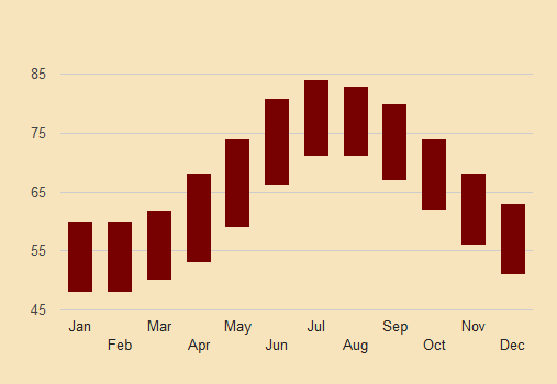
Crete is the most southerly of the major Greek islands, and has hot summers and mild, somewhat wet winters. It doesn't rain as much in the winter on Crete as it does in the more northerly Aegean islands.
Crete, Greece - Best Times to Go
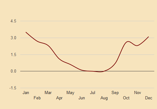
There really isn't a bad time to be in Crete, as far as the weather is concerned. The Maximum average temperature in January is a balmy 62 degrees farenheit. The rains subside in April, so April, May, and September are the most ideal months of low rainfall and reasonable temperatures.
Rains start in October and are frequent until showers taper off in April.
Crete Historic Temperatures and Precipitation
The climate charts below show the historic high and low temperatures and average monthly rainfall for Crete, Greece.
Crete Monthly Precipitation Throughout the Year
Greece Tourist Cities & Islands: Weather and Climate Charts
Athens Crete Crete Corfu Delphi Nafplion Nicosia, Cyprus Rhodes Samos Santorini Skopelos